Thursday, August 04, 2005

Warehouse Woes

The South Brunswick Planning Board approved the 1.4 million square foot warehouse east of the NJ Turnpike from the Pulda Farm and Pigeon Swamp State Park.

Area residents came out in force to question the applicant and the Board on issues of serious concern including the impact of stormwater runoff and traffic.

To our satisfaction, the developer had completely redesigned his retention pond to improve conditions and flooding in the area. While it remains to be seen just how much this will acutally help, this was a major success for our insistence that industrial development in South Brunswick be responsible and sensitive to the environment.

We still have issues with the stormwater runoff despite engineering reports showing it's not a problem. We repeat that eyewitness accounts of how flooding of Green Acres land has coincided with the warehouse runoff being diverted under the Turnpike. It is, in our opinion, a case of the theoretical effect of runoff and the reality opposing each other.

We were also pleased that a last minute decision by the developer to change either the size of his building or the size of his parking lot will bring the impervious coverage of his site into the Township's code requirements. This decreases impervious surfaces--pavements and other surfaces that cannot absorb water but rather create more stormwater runoff--by about 107,000 square feet.

Residents tired of seeing trucks on neighborhood roads damaging lawns and blocking intersections as they try to find their way to the warehouses were not satisfied, but this battle must continue. We all must make every effort to keep these concerns in the public eye and in the eyes of Township officials.

The public outcry cannot be ignored. In this case, the developer responded on his own by making an effort to correct some stormwater issues. High public participation and attendance at the meetings will keep reminding developers to "do the right thing" instead of just satisfying themselves.

To all who attended or took part: Thank you for your dedication. There is much more to do. We will keep you posted on any efforts being made to protect our homeland.
Tuesday, August 02, 2005

Map of the Flooded area

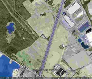
Here is an aerial photo of the area beling flooded.

To the east you can see the lot where the new warehouse is proposed.

To the northeast you can see the current warehouses and their blue stormwater ponds.

West and a bit south of them there is a rectangular outline which is the offending detention pond. All the overflow from the stormwater ponds feed into this pond. (Dry in this picture.)

South along the Turnpike runs a six foot wide drainage ditch.

Following along the Turnpike south, you will see a triangle of green on the west side. That is where the two 54" drainage pipes carry water across to the Green Acres lands.

Northwest lies the Pulda/VanDyke farm.

All the land south and west of that farm is State Parkland. The flooding lies in the tree line just south of the Pulda farm and on the farmland to the southeast of the Pulda tract. You can see a stream bed traced across the farm field leading to those trees. This is caused by the excess runoff coming from the west side of the Turnpike.

EVA has seen this water flowing from the detention pond into the ditch and into the pipes on the east side of the Turnpike. EVA has also seen the water exiting the pipes on the western side, overflowing from the Turnpike drainage area, crossing into the cornfield, and then flowing across into the wooded area, flooding it.

Flood waters vary according to rainfall. During the recent two week dry spell with very high temperatures, the water has receded but is still about two feet deep. After rains and during the Spring thaw, water on the outer edges of the flooded area have been nearly three feet deep. I was not able to risk checking the depth in the central area of the flooding.

Monday, August 01, 2005

Where Are We Now? In a Quandary.


In a Lake of Quandary

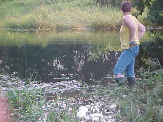
Well, we are still under water on the Green Acres lands, even two weeks after the heavy rains. As you can see the water here is now still over a foot deep as far as I dared wade in. A few more steps and it would have been over the top of my boots.


Concerns now surround future development on the land to the east of the NJ Turnpike.

Engineers involved claim there will be no more stormwater introduced into the drainage area by the new development. The problem is, the five previous developments made the same promises. As you can see, the calculations may have been off.

Prior to warehouse development along Davidson's Mill Road with a series of storm drains, a detention pond, and a drainage ditch feeding water under the NJ Turnpike, the land where I am standing was dry. Maps from 1981 indicate no sign of wetlands here. Now, the land has been flooded since February, with no end in sight.

The new warehouse development proposes a major expansion of the detention pond on the east side of the Turnpike as well as two large drainage culverts running east/west under the building, both emptying into the pipes under the Turnpike. All this does is repeat and expand an already failed stormwater runoff system.

On Wednesday, August 3, the South Brunswick Planning Board will be hearing and voting on an approval of this new warehouse. We need voices to express concern over the repeated flooding of our State parkland.