Map of the Flooded area
Here is an aerial photo of the area beling flooded.
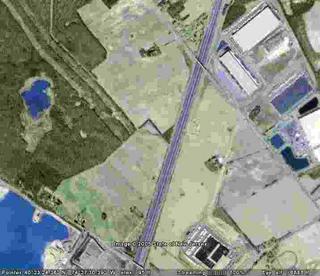
To the east you can see the lot where the new warehouse is proposed.
To the northeast you can see the current warehouses and their blue stormwater ponds.
West and a bit south of them there is a rectangular outline which is the offending detention pond. All the overflow from the stormwater ponds feed into this pond. (Dry in this picture.)
South along the Turnpike runs a six foot wide drainage ditch.
Following along the Turnpike south, you will see a triangle of green on the west side. That is where the two 54" drainage pipes carry water across to the Green Acres lands.
Northwest lies the Pulda/VanDyke farm.
All the land south and west of that farm is State Parkland. The flooding lies in the tree line just south of the Pulda farm and on the farmland to the southeast of the Pulda tract. You can see a stream bed traced across the farm field leading to those trees. This is caused by the excess runoff coming from the west side of the Turnpike.
EVA has seen this water flowing from the detention pond into the ditch and into the pipes on the east side of the Turnpike. EVA has also seen the water exiting the pipes on the western side, overflowing from the Turnpike drainage area, crossing into the cornfield, and then flowing across into the wooded area, flooding it.
Flood waters vary according to rainfall. During the recent two week dry spell with very high temperatures, the water has receded but is still about two feet deep. After rains and during the Spring thaw, water on the outer edges of the flooded area have been nearly three feet deep. I was not able to risk checking the depth in the central area of the flooding.
posted by Jean @ 8:45 AM
0 comments
![]()


0 Comments:
Post a Comment
<< Home